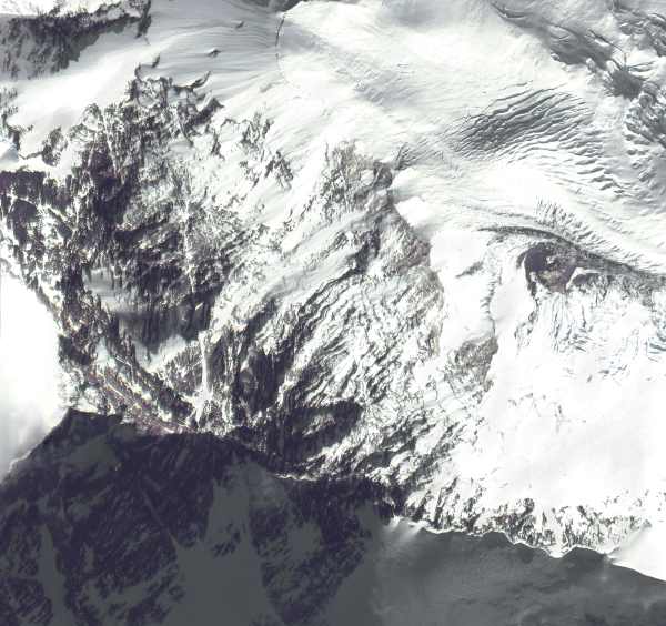
 Click to enlarge the IKONOS portrait of Mount Everest provided by Space Imaging |
Fifty years later, on May 29, 2003, a portrait of Mt. Everest made by the IKONOS commercial photography satellite was released. The satellite was 423 miles above Earth's surface on January 29, 2001, when it snapped the high-resolution picture of Mt. Everest.
To commemorate the 50 year anniversary of the first ascent to the summit of Mt. Everest, Space Imaging released the IKONOS image at right as well as a mountain fly-over movie. In the images, north is down, south is up.
The 1,600-lb. IKONOS satellite was traveling at a speed of 17,500 miles per hour as it flew overhead.
IKONOS was launched into a sun-synchronous orbit of Earth in September 1999 to become the world's first commercial high-resolution remote sensing satellite. Its camera can see objects on the ground as small as three feet square (one-meter square). The name IKONOS is from the Greek word for "image."
Over the years, IKONOS has provided a stream of commercial high-resolution satellite photos. The satellite produces one-meter black-and-white — panchromatic — and four-meter multispectral — red, blue, green, near infrared — images. IKONOS has collected more than one million images of the Earth's landmass on every continent.
IKONOS orbits the Earth every 98 minutes at an altitude of 423 miles (680 kilometers). The satellite's sun-synchronous orbit leads the spacecraft to pass over a given longitude on the surface of the planet at about the same local time each day — 10:30 A.M. IKONOS can produce a photo of the same geography every 3 days.
Learn more:
Satellites index Search STO STO cover E-mail Copyright 2003 SpaceTodayOnline