| Cover | Global Links | Solar System | Deep Space | Rockets |
| Satellites | Space Shuttles | Space Stations | Astronauts & Cosmonauts |
How High Do Satellites Fly?
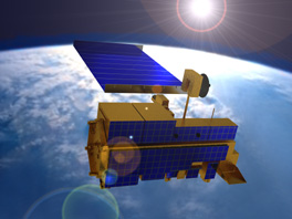
A 21st Century Satellite Orbiting Earth
Earth is ensnared today in a thick spider web of orbits. Satellites with different assignments fly at different altitudes:
U.S. space shuttles are manned satellites of Earth. They usually fly at altitudes around 200 miles above Earth. Rarely, they fly near 400 miles altitude. Russia's orbiting space station Mir is another manned satellite. It maintains its own orbit just above 200 miles altitude.
Russian and American navigation satellites guide ships at sea from 100 to 300 miles altitude.
Photography Photo-intelligence (PHOTOINT) satellites shoot clear pictures and infrared images of installations on the ground from the same altitude range. Radar images of targets on Earth's oceans are recorded at these altitudes.
Civilian photography satellites, such as the American Landsat and the French Spot, orbit at altitudes ranging from 300 to 600 miles. American NOAA and Russian Meteor weather satellites are at these same altitudes.
Spysats and military communications satellites dominate space from 600 to 1,200 miles altitude. The spysats gather electronic intelligence (ELINT), signal intelligence (SIGINT) and radar intelligence (RADINT). Hamsats also operate there.
Science Science research satellites do much of their work at altitudes between 3,000 and 6,000 miles above Earth. Their findings are radioed to Earth as telemetry data.
From 6,000 to 12,000 miles altitude, navigation satellites operate. Best known are the U.S. global-positioning system (GPS) and Russia's equivalent GLONASS satellites.
Altitude in Miles Satellite Types 100-300 shuttles, space stations, spysats, navsats, hamsats 300-600 weather sats, photo sats 600-1,200 spysats, military comsats, hamsats 3,000-6,000 science sats 6,000-12,000 navsats 22,300 (stationary) communications, broadcast, weather 250-50,000 (elliptical) early-warning, Molniya broadcast, communications, spysats, hamsats
The so-called Clarke Belt is the region of space 22,300 miles above Earth where satellites seem stationary above the rotating Earth. Best known occupants of the Clarke Belt are the many domestic and international TV broadcast, weather reporting and communications satellites.
Non-Broadcasters Inmarsats are examples among many non-broadcast communications satellites in the Clarke Belt. Europe's Meteosat and America's GOES are weather satellites in stationary orbits. At the same altitudes, but less-well known, are satellites such as NASA's TDRS (Tracking and Data Relay Satellites), Russia's similar Satellite Data Relay Network (SDRN), U.S. Milstar military communications satellites, the Pentagon's Defense Satellite Communications System (DSCS) and the U.S. Navy's Fltsatcom and Ultra High Frequency (UHF) communications satellites.
The Russians have a series of communications satellites, known as Molniya, in long elliptical orbits which repeatedly carry them out beyond 22,000 miles before they swing back to within 1,000 miles of Earth's surface. Molniyas relay television broadcasts as well as man-in-space and military communications.
Other satellites in such elliptical orbits range from as close as 250 miles out to 60,000 miles. They include intelligence-agency communications craft and early-warning satellites which would report a launch of nuclear weapons.
SatBytes index Satellites main page Space Today Online cover E-mail Copyright 2001 by Space Today Online