| Cover | Global Links | Solar System | Deep Space | Rockets | Satellites | Space Shuttles | Space Stations | Astronauts & Cosmonauts |
Hey! That's Earth on the Web
This was a really cool Internet idea!
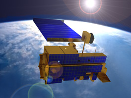
A 21st Century Satellite Orbiting Earth
In the 1990s, U.S. Vice President Al Gore proposed building a space satellite with a color television camera on board and sending it out to orbit a million miles from Earth.
In Gore's plan, the TV satellite would have been ferried to space aboard one of our space shuttles. It would have been dropped off out there and positioned to send down round-the-clock color pictures of our sunlit planet. The pictures would be fed directly to a 24-hour-a-day space channel on the Internet.
Gore figured the pictures would inspire students, as well as provide tremendous scientific value. The mission was named Triana and was to have been launched by December 2000. Unfortunately, the incoming George W. Bush Administration killed the plan. Even so, it still had been a cool idea.
Triana surely would have inspired millions of persons around the globe as it provided its view of Earth for distribution over the Internet.
Triana was to have been supervised by the Scripps Institution of Oceanography at La Jolla, California, and NASA's Goddard Space Flight Center. Officially, it would have been an Earth probe in NASA's series of Earth science spacecraft designed to increase our understanding of the total Earth system and the effects of natural and human-induced changes in the global environment.
Lagrange point. The satellite was to have been parked at a place in space known as L1 -- the Lagrange libration, or neutral gravity point between the Earth and the Sun. From L1, Triana would have enjoyed a continuous, full disk, sunlit view of the Earth. It would have broadcast those sunlit Earth photos live to the Internet.
Triana was selected by NASA after a rigorous peer-review evaluation of nine competing proposals.
The satellite was named for Rodrigo de Triana, the sailor on Columbus's ship who was on lookout duty and first sighted the New World. The ground station network was to have been called Earth-Span.
Science Instruments. Triana would have weighed 330 lbs. and have been five feet in diameter. It was to have carried two scientific instruments -- the Earth Polychromatic Imaging Camera (EPIC) and an advanced radiometer.
Triana also was to have a small, next-generation space-weather monitoring instrument to contribute to our understanding of how solar events affect Earth-orbiting spacecraft, such as communications satellites.
Scientists noted that a radiometer at L1 would look at the whole sunlit side of the Earth at once and give us the first direct measurements of the radiant power reflected by our planet. That would reveal how much of the Sun's energy is absorbed in the Earth's atmosphere.
EPIC would have seen the structure and evolution of Earth's vegetation canopy from a position in-line between the Earth and the Sun. From there, it would have the so-called retro-reflectance "hot spot" view. EPIC also would have observed clouds and aerosols in Earth's atmosphere.
The L1 Advantage. Why not use a weather satellite? Some weather satellites can't transmit ordinary color pictures and are in orbits where they don't see all of Earth. Triana, on the other hand, always would have been looking at the full sunny side of our planet. It would have been much farther away in an orbit a million miles above Earth, compared with weather satellites which are in orbits up to only 23,000 miles above Earth.
At L1, the Sun's gravity exactly counterbalances that of Earth. Stationing Triana at L1 would have enabled it to remain constantly aimed at the hemisphere of Earth that is in fullsunlight. That would have reduced the need for engine firings to maintain its position.
The L1 vantage point, with its full-disk view of the Earth, offered unique scientific advantages. Full-disk means the full globe is seen all at once. Before Triana, photos by satellites in low orbits up to several hundred miles above Earth, or geostationary orbit at 23,000 miles above Earth, would have had to have been stitched together to form a full-Earth view. The stitching would have required a concerted effort to process out differences due to viewing times and revisit intervals.
In fact, L1 would be a prime vantage point for many spacecraft in the next generation of remote-sensing instruments looking down on Earth. Triana would have been a pathfinder for those future missions, providing scientific and operating experience at L1.
Apollo Icon. The full-Earth images transmitted by Triana would have been better than the famous portrait of the blue planet recorded by Apollo 17 astronauts in 1972. Triana would have shown surface features as small as five miles square, as well as the motions of clouds, hurricanes, large fires, and other events as they happened.
Triana would have carried an eight-inch telescope and a three-color camera capable of twice the sharpness of high-definition TV. The images would have been refreshed every few minutes. Ground stations would have been operated by university students, in keeping with the Clinton Administration's effort at that time to increase interest in science and math.
Participants. Students and the educational community would have been involved in every phase of the inspirational Triana project. Students would have benefited from hands-on participation via the Internet and NASA's other educational outreach efforts.
Commercial enterprises were to have participated in the Triana mission by contributing financially to spacecraft development in exchange for commercial rights to data. NASA's Goddard Space Flight Center was to provide a Small Explorer spacecraft and ground control system for Triana, as well as program integration and management support.
Learn About GOES Weather Satellites
SatBytes index Satellites main page Search STO STO cover E-mail Copyright 2003 by Space Today Online