| SPACE TODAY ONLINE COVERING SPACE FROM EARTH TO THE EDGE OF THE UNIVERSE | ||||||||||
| COVER | SOLAR SYSTEM | DEEP SPACE | SHUTTLES | STATIONS | ASTRONAUTS | SATELLITES | ROCKETS | HISTORY | GLOBAL LINKS | SEARCH |
The Planet Earth:Radar Reveals Hidden Remains at Ancient Angkor
Remnants of ancient temples from prehistoric civilizations have been discovered at Angkor, Cambodia, by researchers using highly detailed maps produced with data from an imaging radar.
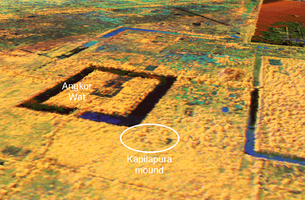
Click to enlarge NASA image of Angkor [175k]
Angkor is a vast complex of some 1,000 temples covering about 100 square miles of northern Cambodia. The Airborne Synthetic Aperture Radar (AIRSAR) developed by NASA's Jet Propulsion Laboratory (JPL), Pasadena, California, has revolutionized the way archaeologists view the way the city developed in ancient times. [CLICK IMAGE FOR MORE PICTURES]
Little is known of the prehistoric occupation of the fertile Cambodian flood plain. However, at its height the city probably housed a million people. Its now-famous temples were built in the time from the eighth to thirteenth century AD. They were accompanied by a massive hydrological system of reservoirs and canals.
Lost in the forest. Today, much of the civilization of Angkor is hidden beneath a dense forest canopy. It is inaccessible due to poor roads, military land mines and political instability.
The new radar has enabled scientists to detect a circle of prehistoric mounds and undocumented temples far to the northwest of Angkor. The site's topography is highlighted by the radar, focusing attention on previously neglected features, some at the very heart of the city.
Radar maps not only bring into question traditional concepts of the urban evolution of Angkor, but reveal evidence of temples and earlier civilization either absent or incorrect on modern topographic maps and in early twentieth century archaeological reports.
The radar images make apparent many features that are not readily identifiable on the ground. Scientists can see differences in vegetation structure and some features that are obscured by vegetation cover.
Angkor Wat. In December 1997, the radar was used to survey a small mound on the perimeter of the famous 12th century AD temple, Angkor Wat. The mound had been noticed first in a radar image.
Previous archaeological accounts, from 1904 and 1911, noted only two temples at Angkor Wat and did not mention the circular form of the mound. The 1997 radar images led to four to six temple remains, including pre-Angkorean structures. They suggested the 12th century site actually had been occupied some 300 years earlier.
Ancient beauty. Angkor's beauty is seen in its temples, but the greatness of the Khmer city lies in the multitude of water-related constructions. The Khmer kings nominally dedicated temples to Hindu and Buddhist deities, but the underlying significance was veneration of ancestral spirits, ensuring fertility of the land.
Management of water was essential, both for flood control during monsoon rains and water conservation during dry seasons. Management included the construction of moats, dikes, canals, tanks and reservoirs. The largest of reservoir, dated to the 12th century AD, and is five miles long. Its function remains is debated by archaeologists.
The new detailed topographic maps have revealed many more hydrological features and highlighted how they function in the rituals and daily life of the Khmer people.
Interferometry. The technique known as radar interferometry combines two images to create a three-dimensional topographic map. Through interferometry, researchers can construct a map of the area surrounding Angkor that is more accurate than most maps of the United States. The map shows clearly both natural and human-engineered water management features at the site.
Angkor is situated on the edge of the Tonle Sap lake. That unique body of water doubles in size during the rainy season. The maps give new insights into the human impact on the lake's ecosystem, from the ancient Khmer to the present day, showing how the Earth has changed in that region.
Space shuttle radar. The Angkor radar images were taken in late 1996 as part of the AIRSAR Pacific Rim Deployment. They were a follow-up to the 1994 study of Angkor in which a Spaceborne Imaging Radar-C/X-band Synthetic Aperture Radar (SIR-C/X-SAR) collected data from aboard NASA's space shuttle Endeavour.
Endeavour
Like SIR-C/X-SAR, AIRSAR transmited and receiveed three radar frequencies in both horizontal and vertical polarizations. While both systems use C-band and L-band radio wavelengths, AIRSAR has the added benefit of P-band, a longer radio wavelength that can penetrate below the forest canopy. In addition, AIRSAR can be flown in a mode called TOPSAR that allows it to measure topography and create three-dimensional images of the surface.
AIRSAR flies on a NASA DC-8 aircraft that is managed at NASA's Dryden Flight Research Center, Edwards, California. AIRSAR is managed by Jet Propulsion Laboratory (JPL), a division of the California Institute of Technology, for NASA's Office of Earth Science, Washington, D.C.
NASA's Office of Earth Science manages NASA's internationally coordinated effort to study natural and human-induced changes in the Earth's land, oceans, atmosphere, ice and life.
The AIRSAR flight over Cambodia was funded by the Government of Thailand. Ground verification was made possible by the Minister of State for Culture and Fine Arts, Territorial Management, Urban Planning and Construction; and the Cambodian Authority for the Protection and Management of Angkor and the Region of Siem Reap.
Learn more: AIRSAR images of the Angkor region
Inner Planets: Mercury Venus Earth Mars Outer Planets: Jupiter Saturn Uranus Neptune Pluto Other Bodies: Moons Asteroids Comets The Voyagers
Solar System index STO Cover Search STO Questions Top of this page About STO Feedback
© 2006 Space Today Online