| Satellite Tracking |
Birds | Land Animals |
Marine Animals |
Fish | Internet Resources |
| Satellite Tracking |
Birds | Land Animals |
Marine Animals |
Fish | Internet Resources |
A wildlife-tracking satellite looking down on a wide area of the globe from its high vantage point is a useful tool for biologists, naturalists and conservationists working with animals, birds and fish in their natural environments.
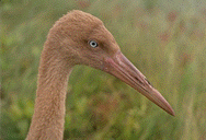
'Vodka' is an endangered Siberian Crane tracked by the Patuxent Wildlife Research Center and NASA's Goddard Space Flight Center, which use satellites orbiting over Earth to monitor migration routes of endangered species.
Data collected through satellite tracking helps us understand and protect the endangered and threatened species of the world.
Scientists have attached tiny transmitters to wild animals for years, tracking their radio signals with receivers nearby on the ground. Now they track wildlife ranging over much wider areas with receivers high above the ground.
A receiver in an orbiting space satellite can hear a transmitter attached to an animal. Even if the animal is out of sight over the horizon from a tracker on the ground, a satellite high in space still can hear the transmitter and repeat its signal down to trackers on the ground.
How Animals Are Tracked
To track a bird or animal on the ground or in the air, scientists strap a tiny radio transmitter to the animal, bird or fish. Information collected from the animal, bird or fish is impressed on a signal sent from the transmitter up to a NOAA weather satellite orbiting far above Earth.
NOAA is the National Oceanic and Atmospheric Administration, the Weather Bureau people. NASA is the National Aeronautics and Space Administration.
A signal sent up to a satellite is known as an uplink. A signal sent down from a satellite to a ground station is a downlink.
At the end of the transmission link, the data from the tracked animal, bird or fish goes to the wildlife researchers.
The Transmitters
The transmitter is a miniature electronic device designed for locating and tracking wildlife. It sends data about the bird or animal's environment to a special section of a NOAA weather satellite known as the ARGOS Data Collection System.
The transmitter is carried in a harness strapped to the animal or bird's body. Each harness is custom-designed for each species and manually adjusted for each bird or animal for maximum comfort and fit.
The Satellites and Ground Stations
As the NOAA weather satellite flies along its orbit above an animal or bird's location, the ARGOS section of the satellite receives and stores the uplinked data. Later, as the NOAA satellite passes over a ground station, ARGOS downlinks the information to the ground station.
The downlinked data received by the ground station is sent on to NASA's Goddard Space Flight Center where it is analyzed and the information about the animal or bird is extracted.
What do we learn from the data?
Most importantly, the data reveals the location of the animal or bird when the original signal was transmitted.
In addition, several other kinds of information may be sent up from the bird or animal to the satellite. The information depends on the manufacturer and purpose of the radio transmitter. For instance, the data might include the local temperature where the animal or bird is. Here are some other kinds of information:Maps of Migration Routes
- Animal/Bird Activity is determined by a small motion-activited switch in the transmitter pack. As an animal or bird changes positions, the switch is turned on or off by the motion. How useful is that? If the switch is off in one message and on in another, researchers assume the bird or animal is active. If the switch stays on or off, researchers assume the animal or bird is inactive.
- Animal/Bird Latitude/Longitude is determined as the transmitter sends signals to the NOAA satellites. A satellite can determine the speed with which it is approaching a transmitter by measuring the so-called doppler shift of the radio signal frequency. The speed meaurement is transmitted to a ground station along with the data. As a ground station receives several downlinks, it calculates the location of the transmitter attached to the animal or bird.
- Battery voltage depends on battery charge and temperature. Colder temperatures slow the chemical reactions in a battery and reduce the power available to the transmitter. Battery voltage can reveal temperature around the transmitter.
One place satellite tracking data is sent is the Patuxent Wildlife Research Center where researchers are studying habitats and migration routes of birds. The satellite tracking data is converted into maps and animations of bird activities.
NASA locates a picture of the bird or animal on a map on the Birdtracks web page.
Learn more:
An STO reader asks: Does satellite tracking hurt an animal or bird?
Technology: How Doppler satellite tracking works
Satellite
TrackingBirds Land
AnimalsMarine
AnimalsFish Internet
Resources
Copyright 2001 Space Today Online Satellites main page E-Mail