» March 31, 2004: Spirit and its rover twin, Opportunity, ended the month of March 2004 by preparing to enter a new phase of martian exploration. In April, the prime three-month missions of Spirit's and Opportunity will end and their extended missions will begin.
NASA's Jet Propulsion Laboratory at Pasadena, California, built the Mars cruisers to rove across the landscape for 90 martian days. A martian day, known as a sol, lasts about 40 minutes longer than a day on Earth.
Because both rovers are healthy as they approach the end of their 90-day assignment, and probably will be able to operate for several additional months, JPL plans to extend their assignments.
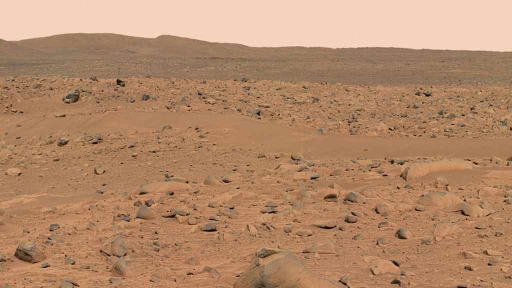
When Spirit landed inside the 95-mile-wide Gusev Crater 12 weeks ago, its main assignment was to find geological clues about whether the region ever had a wet environment.
Spirit spent a good deal of time driving toward a 660-foot-wide crater named Bonneville. The JPL team had thought the impact eons ago that excavated Bonneville Crater might have ejected rocks old enough to hold clues about whether Gusev held water.
Unfortunately, the object that struck Bonneville didn't dig in deep enough to get below the volcanic layer. So, after finishing its work on the crater's rim, the rover headed for the hills.
Today, Spirit has left Bonneville Crater behind and is trekking southeast across the plain toward Columbia Hills, a range of peaks which seem to be an island of older rock atop a surrounding layer of younger volcanic surface material.
Geologists think older rocks may hold evidence of an ancient body of water they suspect once filled Gusev Crater.
On the way from Bonneville Crater to Columbia Hills, the rover will stop from time to time to inspect small craters and a dark streak apparently left by a whirlwind that removed dust.
The distance to Columbia Hills is about 1.3 miles. It will take the rover 60-90 days (sols) to make the trip.
Picture: looking away at ColumbiaHills
Opportunity, like its rover twin Spirit, is starting a long trek. It has climbed out of the small impact basin, named Eagle Crater, where it landed nine weeks ago. An outcropping of bedrock inside the crater provided evidence that the site was once under flowing water. In coming weeks, Opportunity, will drive about half a mile to a crater the JPL team calls Endurance. There, geologists hope to find thicker bedrock to learn more about the duration of the region's wet history.
Before leaving Eagle Crater, Opportunity, inspected the martian soil at five sites in the opposite half of the crater from the outcropping of bedrock. The patches of soil revealed a variety of sizes and shapes of surface particles. Geologists suggested the martian wind may have blown some small particles away and left large particles behind.
Those tiny gray spheres that have been fancifully called blueberries are plentiful in some soil patches higher on the inner slope of the crater than near the center of the crater. A reading by Opportunity's Mössbauer spectrometer on one of the higher patches found the highest concentration of hematite seen so far in the mission. The type of hematite Opportunity has been finding usually forms on Earth under wet environmental conditions.
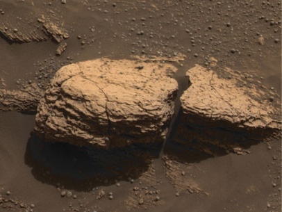
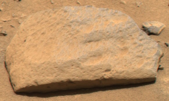
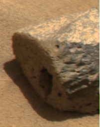
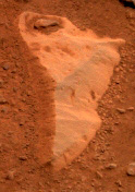
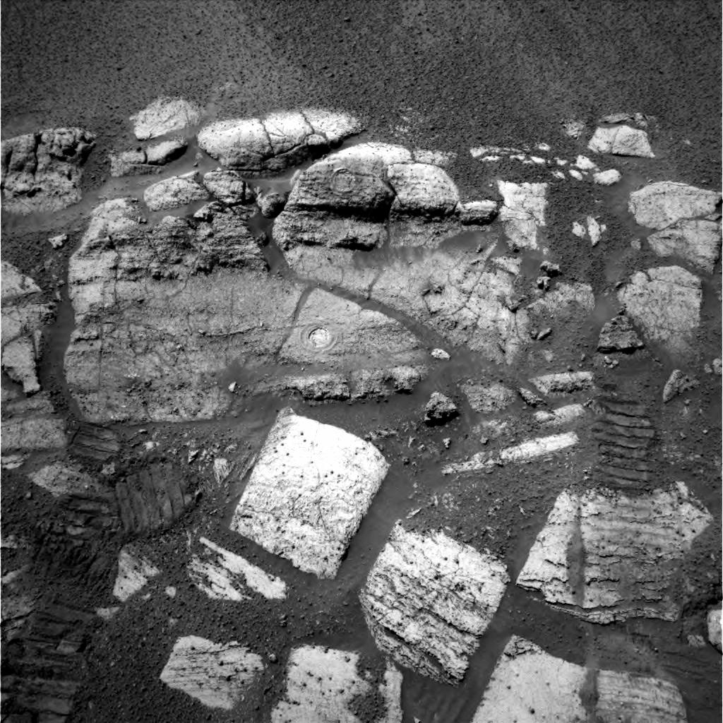
» March 25, 2004: Spirit brushed off and ground into the areas called New York and Illinois on the rock Mazatzal with the rock abrasion tool. It analyzed them with its spectrometers and photographed them with the microscopic imager and panoramic camera. Mazatzal stood out to the Mars Exploration Rover scientists because of its large size, light tone and sugary surface texture.
Picture: Mazatzal
Picture: New York and Illinois brushed clean
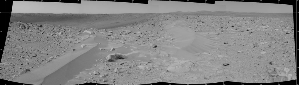
» March 19, 2004: Spirit dug into the side of a drift named Serpent and used its microscopic imager to snap pictures, which revealed pea-shaped grains with diameters from 0.04 and 0.08 inches. They are similar to grains the rover found in other drift areas in Gusev Crater. Together, the large grains form a layer of crust on the surface of the drift and are covered in a fine layer of martian dust. On Earth, grains of sand in drifts or dunes usually are about 0.008 inches in diameter. Sand dunes form on Earth when particles are bounced across a surface by wind and collect together as drifts. Smaller particles, like the ones in the Serpent drift on Mars, would not necessarily collect into a dune on Earth, but would more likely be distributed across the surface like dust. The fine grains making up the interior of Serpent drift are no larger than 0.002 inches and can be compared to silt on Earth.
Picture: Serpent drift
Picture: drifts in Bonneville Crater
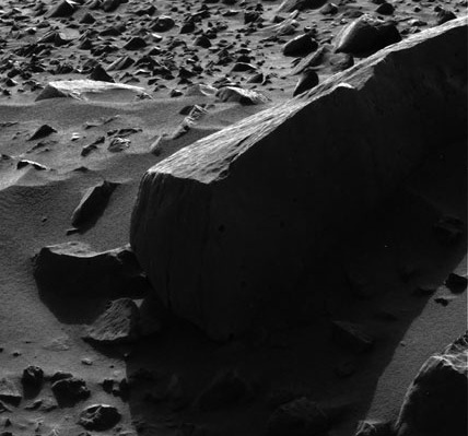
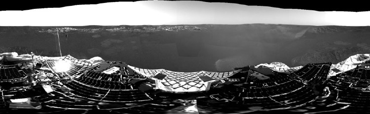
» March 13, 2004: From the rim of Bonneville Crater, Spirit is looking down into the 656-ft.-diameter bowl in the ground. The rover began its work there by moving its panoramic camera to shoot a high-resolution 360-degree view of Bonneville's rim and basin as well as the Columbia Hills to the southeast. The rover is close enough to the edge to see the interior of the crater, but high enough and far enough back to get a view of all of the walls. Meanwhile, a navigation camera mosaic of the crater shows the rover's heatshield, which is visible as a tiny reflective speck just above the far crater rim, on the left side. Spirit will stay at its current position for two days.
Picture: Spirit at the rim looking in
The rover moved its robot arm – known officially as the instrument deployment device – so it could photograph the magnets on the rock abrasion tool. Next, it took microscopic images of the soil in front of the rover and placed the Moessbauer spectrometer on the soil to collect data. Next, it will perform remote sensing of the inside of the crater and analyze soil targets with the Messbauer and alpha particle x-ray spectrometers.
Illustration: Spirit graphic on the rim
Many of the rocks previously examined by Spirit along the way to Bonneville probably had been ejected from the crater eons ago when it was formed by an object impacting the surface of Mars. For instance, if a meteorite slams into the ground and creates a crater, it throws surface debris out to the sides, revealing older material buried in the crater. Geologists hope to find an exposed layer of ancient bedrock outcropping inside the crater.
Illustration: 3-D model of the rock Humphrey
Spirit used its navigation camera and its panoramic camera to snap the first photographs ever taken of Earth from the surface of a planet beyond the Moon. It was taken one hour before sunrise on the rover's 63rd martian day, or "sol." The final image is a mosaic of the navigation camera showing a broad view of the sky and the panoramic camera image of Earth. The contrast in the panoramic camera image was increased two times to make Earth easier to see. An inset shows a combination of four panoramic camera images zoomed in on Earth. The arrow points to Earth. Earth was too faint to be detected in images taken with the panoramic camera's color filters.
Picture: Earth as seen from Mars
» March 12, 2004: Spirit reached the edge of Bonneville Crater from where it took a look inside the crater and sent back navigation camera images.
Picture: Bonneville Crater
» March 11, 2004: Spirit looked up with its panoramic camera for a nighttime observation of the constellation Orion the Hunter in the martian sky. The bright star Betelgeuse and Orion's three-star belt appear in the eight-second exposure.
Picture: Orion the Hunter
» March 10, 2004: Spirit analyzed Serendipity Trench, then resumed its drive to Bonneville Crater. In the longest directed drive to date, the rover rolled 88.6 feet toward the rim of the crater. Spirit then used its auto navigation capability to reach a target that was 19.7 feet away. The rover couldn't go directly to the target. It had to drive back and forth. Those maneuvers brought the day's total distance covered to 133.5 feet, even though the total straight-line distance traveled was only 98.4 feet.
Story: How They Drive The Distance
At any rate, the drive put Spirit close enough to Bonneville it could shoot photos with the navigation cameras revealing the opposite rim of the crater. Next, the rover will drive up to the summit of the crater rim and use the navigation camera to show the JPL team what's inside the crater. Scientists are excited about seeing the floor and walls of the crater, where layers may be exposed that are older than materials on the surface outside of the crater. The 360-degree navigation camera mosaic photograph taken by the rover from 66 feet away from the rim of the crater provided a glimpse of the far side of the rim. It included a close-up of a 3.3-ft.-tall rock named The Hole Point. That rock served as a landmark for rover drivers guiding the rover toward the crest of the crater rim.
Picture: 360-degree photo mosaic
Spirit took time recently to use its rear navigation camera for a look back along the path it had traveled from its landing platform. The March 6 photo revealed the rocky 787 ft. path that the rover had traveled since arriving at Gusev Crater on January 3, 2004. In the picture, the lander can still be seen in the distance. It never again will be home for the rover. The JPL team also saw in the image the effectiveness of the rover's autonomous navigation system used during parts of Spirit's drives. For instance, instead of driving directly through the shallow hollow that can be seen at middle right in the image, the autonomous navigation system guided Spirit around the high ridge bordering the hollow.
Picture: looking back along the path
» March 9, 2004: Spirit drove 94 feet closer to the rim of Bonneville Crater. To date, the rover has covered a total of 1,030 feet. That's 45.9 feet beyond the distance listed beforehand by NASA as the minimum for mission success. To complete the 94 feet, Spirit began by traversing 59 feet of that rough field of rocks under direct command from the drivers on the JPL team in California. It then used its autonomous navigation system to cover an additional 35 feet. During the drive through the rocks, the rover had difficulty finding its way around an obstacle. To go forward, it had to wiggle back and forth. That gouged out a shallow trench, which gave the JPL scientists a new hole to have the rover peer down into. They named it Serendipity Trench.
Picture: rock obstacles
» March 8, 2004: On the way to Bonneville Crater, Spirit used its panoramic camera to photograph the rocky terrain ahead. Some rocks on the horizon may be at the rim of Bonneville more than 200 feet away.
Picture: rocky field ahead
A navigation camera photo shows the rocky path east of the rover. Boulders as tall as 1.6 feet dot the landscape near Bonneville Crater. East Hills are 1.3 miles away on the far right. Spirit will take a safer route than this to get to the rim of Bonneville Crater.
Picture: rock field and East Hills
» March 7, 2004: Spirit is rolling along toward the rim of Bonneville Crater. It has covered about one-fifth of the distance from its last stop, the rock Humphrey where it found signs of water. The rover recorded images and infrared readings of the ground in front of it. The drive of 85.8 feet brought Spirit's total distance driven on Mars to 822.5 feet. Because the drive included maneuvers around obstacles, the net gain in the northeasterly direction toward the Bonneville Crater rim was 72 feet. Thus, the crater now is about 289 feet away.
Picture: inside Humphrey
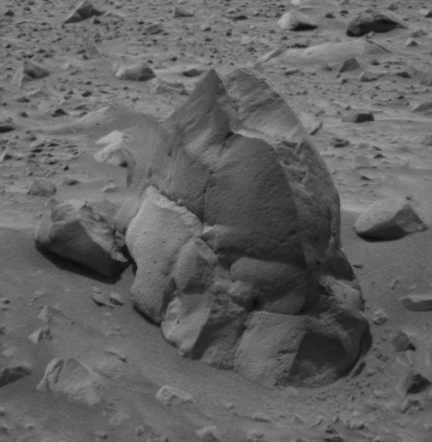
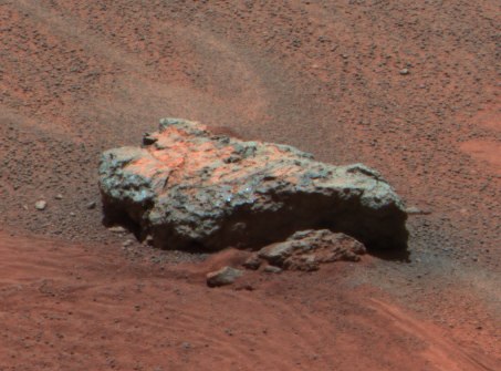
» March 5, 2004: More water found on Mars. Spirit has found a water history in the rock Humphrey at Gusev Crater, but the rock is a different type of rock from those in which Opportunity found a wet past on the far side of the planet. In its interior crevices and cracks, the two-ft.-tall Humphrey has bright material that looks like minerals crystallized out of water. The amount of water suggested by the crystals is considerably less than the amount indicated by the minerals and structures Opportunity uncovered in rocks at Meridiani Planum. Spirit is headed toward the 500-ft.-wide Bonneville Crater, where the JPL team hope to find rocks from beneath the volcanic surface layer. The rim of Bonneville is some 443 feet northeast of the rover's current location.
Picture: Humphey's dill hole
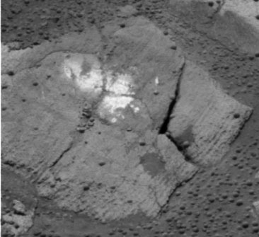
» March 4, 2004: Spirit ground 0.08 inches into the surface of the rock Humphrey, then brushed it for five minutes to clean the surface. The rover used its Moessbauer spectrometer, alpha particle X-ray spectrometer, miniature thermal emission spectrometer, microscopic imager, and panoramic camera to record data. Spirit is about halfway to Bonneville Crater. Later, Spirit will resume its trek to the rim of Bonneville some 443 feet northeast of the rover's current location.
Picture: the road behind
Picture: the road ahead
» March 2, 2004: Spirit used its alpha particle X-ray spectrometer to record data from the spot it had brushed off of the surface of the rock Humphrey. The panoramic camera snapped some multi-spectral shots of the surrounding ground. Then the M–ssbauer spectrometer collected data. When slopes and cracks on the surface of Humphrey made it hard for Spirit's rock abrasion tool to grind effectively, the rover's software stopped the work after four hours, to be continued the next day. The navigation camera atop the mast photographed the results of the brushing of Humphrey with the rock abrasion tool. Three dark circles on the two-ft.-tall Humphrey were made in about 15 minutes of brushing with the RAT. The two upper brush marks aren't completely round due to the rock's slopes, which make it difficult to place tools on a flat surface.
Picture: Humphrey brush marks

|
» March 31, 2004: Opportunity, like its rover twin Spirit, is starting a long trek. It has climbed out of the small impact basin, named Eagle Crater, where it landed nine weeks ago. An outcropping of bedrock inside the crater provided evidence that the site was once under flowing water. In coming weeks, Opportunity, will drive about half a mile to a crater the JPL team calls Endurance. There, geologists hope to find thicker bedrock to learn more about the duration of the region's wet history.
Picture: watery clues
Before leaving Eagle Crater, Opportunity, inspected the martian soil at five sites in the opposite half of the crater from the outcropping of bedrock. The patches of soil revealed a variety of sizes and shapes of surface particles. Geologists suggested the martian wind may have blown some small particles away and left large particles behind.
Story: patches of martian soil
Those tiny gray spheres that have been likened to blueberries are more plentiful in soil patches higher on the inner slope of Eagle Crater. A reading by the rover's Mössbauer spectrometer on one of the higher patches found the largest concentration of hematite seen so far on the martian surface. The type of hematite Opportunity found usually forms on Earth under wet conditions.
Picture: Opportunity sees blueberries
Picture: blueberries on Shoemaker's Patio
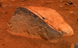
» March 30, 2004: Opportunity visited a big stone the JPL team named Bounce because the lander, inside its protective airbags, had bounced on the rock as it touched down in Eagle Crater. The rover used its rock abrasion tool to grind into Bounce.
Picture: Bounce Rock
» March 26, 2004: Opportunity used its panoramic camera for a wide shot, which the JPL team named Lion King because its view from a high vantage point reminded them of the view from Pride Rock in the movie The Lion King.
Picture: Lion King
» March 25, 2004: Opportunity took a panoramic photo of the plain while moving in for a look at an area called Bright Spot.
Picture: looking back at Eagle Crater
» March 23, 2004: Water once was on Mars' surface. Opportunity has found rocks that look like they were formed eons ago as deposits at the bottom of a body of gently flowing saltwater. The rover is parked on what was once the shoreline of a salty sea on Mars where patterns in layered rocks indicate sand-sized grains of sediment were shaped into ripples by water two inches deep, possibly much deeper, flowing at a speed of 4 to 20 inches per second. It may have been a salt flat covered sometimes by shallow water and dry at other times. On Earth, similar land at the edge of oceans or in desert basins can have currents of water that produce the type of ripples seen in the Mars rocks. It's not clear just how long ago liquid water covered the area. Chlorine and bromine in the rocks also suggest Opportunity is sitting where an ancient sea once lapped its shoreline. To gather more evidence, the rover will drive across a plain toward a thicker exposure of rocks in the wall of a crater.
Press Release: Standing Water Marks Rocks
A photo of the martian rock Upper Dells shows fine layers that are truncated, discordant and at angles to each other. Cross-lamination indicates the sediments that formed the rock were laid down in flowing water.
Picture: watery clues
» March 22, 2004: Opportunity slipped a bit on the inner sidewall of Eagle Crater, then drove up and out onto the surrounding plain known as Meridiani Planum. It stopped for the night about 29.5 feet outside of the crater. As the rover perched at the lip of Eagle Crater, it looked back down into its former home.
Picture: looking back down
» March 21, 2004: Opportunity surveyed patches of soils in various parts of Eagle Crater and found some interesting differences. The rover used its spectrometers and microscopic imager at each soil patch. While driving around the crater, Opportunity's odometer exceeded 388 feet, surpassing the total distance driven on Mars by the Pathfinder lander's rover Sojourner back in 1997.
Story: patches of martian soil
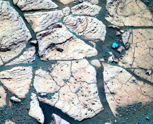
» March 18, 2004: Opportunity has found hematite in the spherules, known to the JPL team as blueberries, embedded in the bedrock outcrop and scattered over some areas of soil inside the small crater where the rover landed two months ago. The blueberries are the size of BBs and look more gray than blue. While individual blueberries are too small for the rover to analyze, it was able to examine a bunch of the berries that happened to be close together in a depression in the rock Berry Bowl. The M–ssbauer spectrometer saw a big difference between the spherules and a different area of the underlying rock. That meant the major iron-bearing mineral in the berries is hematite. On Earth, hematite with a crystalline grain of the size of the blueberries usually forms in a wet environment.
Picture: Opportunity sees blueberries
Picture: blueberries on Shoemaker's Patio
Press Release: berries and water
» March 16, 2004: Opportunity sniffed around an area the JPL team calls Shark¼s Cage in the Shoemaker¼s Patio neighborhood at the extreme southwestern end of the bedrock outcropping in Eagle Crater on Meridiani Planum. The surface features there have names such as Shark¼s Tooth, Shark Pellets, and Lamination. Shark¼s Tooth is the red material filling cracks in the outcrop. Shark Pellets is a soil patch. Lamination has very thin layers that look something like pages in a book. The rover¼s front left wheel was used to scuff a rock called Carousel to determine the hardness of the rock.
Picture: Shark's Cage
» March 13, 2004: Opportunity moved on from Mojo 2 to examine an area named Berry Bowl, photographing it and measuring it with science instruments. Berry Bowl is located within the outcropping of bedrock that lines the inner edge of Eagle Crater where the rover landed. The name Berry Bowl is appropriate because many of those small, dark, spherical objects the JPL team calls "blueberries" have collected in a depression on the surface. Geologists would like to know the chemical composition of the blueberries.
Picture: blueberries
Picture: Berry Bowl area
The panoramic camera recorded images of a rock called Fool's Silver, which has an interesting angular shape. Opportunity also used its panoramic camera to photograph the Sun, trying to catch an eclipse by a martian moon. One image shows the moon Deimos passing in front of the Sun. Deimos passed slightly closer to the center of the Sun than expected, and arrived about 30 seconds early. That observation will help astronomers on Earth refine our knowledge of the orbit and position of Deimos.
Picture: Deimos in front of the Sun
Other photos illustrate the passage of the moon Phobos across the Sun. The observation will help refine our knowledge of the orbit and position of Phobos.
Picture: Phobos crosses the Sun
In addition, the rover used its miniature thermal emission spectrometer to look up into the sky and record the atmosphere. Next, the rover will drive 33 feet to the rock Shark's Tooth in an area known as Shoemaker's Patio.
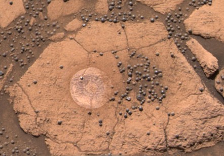
» March 10, 2004: Opportunity is halfway through its primary 90-day mission on the surface of Mars. The rover used its rock abrasion tool brush to sweep the dirt off the Mojo 2 hole in Flat Rock. It then took five microscopic images of Mojo 2. The panoramic camera photographed the Mojo 2 and an area named Slick Rock. The miniature thermal emission spectrometer measured three places on the surface, and then looked upward to observe the atmosphere in four different directions. Next, the rover will use the science instruments on an area named Berry Bowl.
Picture: tilted outcrop
» March 9, 2004: Opportunity used the rock abrasion tool for one hour five minutes to finish grinding a hole slightly more than one-tenth of an inch into the Mojo 2 section of the rock named Flatrock. Then the rover used its M–ssbauer spectrometer on the hole, followed by the alpha particle X-ray spectrometer. Meanwhile, the miniature thermal emission spectrometer measured the atmosphere above and the panoramic camera recorded images of the hole and surrounding areas.
Picture: the hole in Flatrock
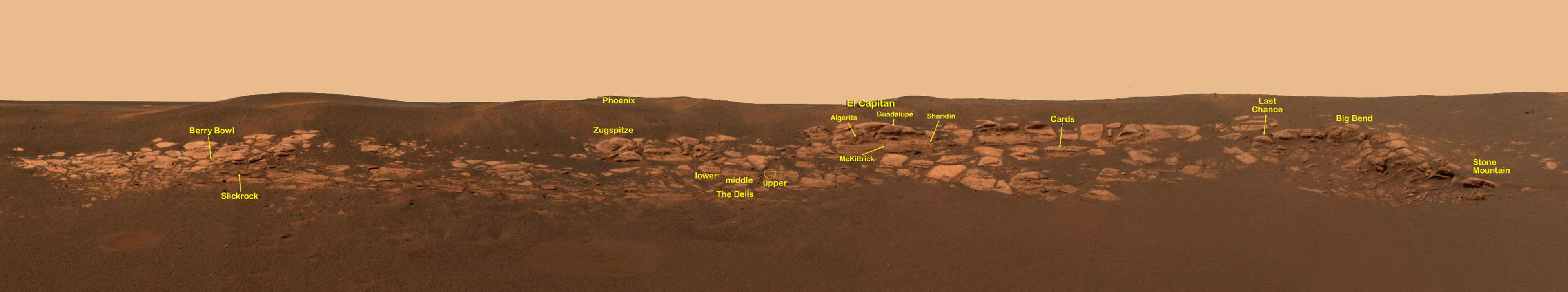
Earlier, Opportunity had checked out the east end of the bedrock outcropping in Eagle Crater where the rover landed. Now it has made its way west along the outcrop to a rock named Flatrock in an area the JPL team calls Slickrock. Flatrock is a very fine layered rock, which may preserve the record of sediment accumulation that occurred millions of years ago ago. The layers are only a fraction of an inch thick with a mineral composition that makes them resistant to erosion. The crystal casts, or vugs, seen at El Capitan are not seen in Flatrock.
Picture: the rock named Flatrock
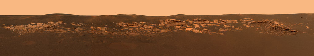
The JPL team has attached many colorful names to the rocks examined by Opportunity, including such monikers as El Capitan, Last Chance, Sharkfin, Wave Ripple in a section nicknamed The Dells, Wave Ripple, and Berry Bowl.
Picture: name tags on the rocks
» March 8, 2004: Opportunity didn't make much of an impression on Flat Rock, so it will need to try again to grind a shallow hole with the rock abrasion tool (RAT). The rover pressed its alpha particle X-ray spectrometer against Flat Rock for an overnight reading to identify the chemical elements present. Meanwhile, the results are in from Opportunity's attempt to shoot the moon – Deimos and Phobos, that is. The rover's panoramic camera recorded the images as the first in a series of eclipse observations by both Opportunity and Spirit. The irregularly shaped moon Deimos is only 9 miles across in its longest dimension so it appears as just a speck in front of the disc of the Sun. Phobos, on the other hand, is 17 miles in its longest dimension so it appears to take a bite out of the edge of the Sun. In fact, it looks even larger when compared with Deimos because Phobos orbits much closer to the surface of Mars than Deimos does.
Picture: moons eclipsed
» March 7, 2004: Opportunity snapped 114 microscope photos of the layering of the rock Last Chance. The job required more than 400 commands and more than 200 positions of the rover's robotic arm.
Picture: rock Last Chance
Both of the Mars exploration rovers carry magnets supplied by Denmark for analyzing martian dust. Most of the dust particles in the martian atmosphere are magnetic. Dust covers much of Mars' surface and hangs in the atmosphere, occasionally blowing up into giant dust storms.
Illustrations: magnets on rover
Opportunity's panoramic camera recorded a new set of pictures of the rover's likely destination after finishing work in and around the small 72-ft.-diameter Eagle Crater where it landed. From partway up the inner slope of the current crater, the rover has a good view of the rim of Endurance Crater, which is about 10 times as big and about 2,300 feet to the east. The JPL probably will have Opportunity roll up and out of its current small crater and drive on toward the larger Endurance Crater. The new pictures across the flat plain of Meridiani also show the rover's landing heat shield, a trail of marks left by the airbag bounces, and a lone dark rock about 16 inches across.
Picture: plain panorama
» March 5, 2004: A two-inch yellowish object shaped like rabbit ears and sitting on the Meridiani plain near Opportunity has caused a sensation among Mars watchers. What is the mysterious object? Could it be a piece of airbag material or something else?
Story: bunny chase on Mars
Picutre: is it a bunny or what?
» March 4, 2004: Having confirmed that liquid water once flowed through the rocks at Meridiani Planum, Opportunity observed the atmosphere overhead with its panoramic camera and miniature thermal emission spectrometer. Then, the rover turned that spectrometer down to stare at the ground for science observations. Later, Opportunity took stereo microscopic images and M–ssbauer spectrometer readings of a soil area the JPL team calls Pay Dirt. Then, Opportunity turned its attention to the rock Last Chance and snapped some panoramic camera photos. The rover moved 16 inches closer to Last Chance so it could use the various tools at the end of its robotic arm. Next, Opportunity will take pictures of a rare solar transit of the martian moon, Deimos. The solar transit of Deimos causes a solar eclipse only twice a year on Mars. One Mars year is about two Earth years.
Picture: once water soaked El Capitan
» March 2, 2004: Liquid water once flowed on Mars. Geologists have concluded that the part of Mars around Opportunity was soaking wet in the past. Evidence in the bedrock outcropping led to the conclusion. Sulfates in the rock and its physical appearance with niches where crystals grew made the case for a watery history. Dr. Steve Squyres of Cornell University, principal investigator for the science instruments on the twin rovers, said, "Liquid water once flowed through these rocks. It changed their texture, and it changed their chemistry. We've been able to read the tell-tale clues the water left behind, giving us confidence in that conclusion." Dr. James Garvin, NASA lead scientist for Mars and lunar exploration, said, "NASA launched the Mars Exploration Rover mission specifically to check whether at least one part of Mars ever had a persistently wet environment that could possibly have been hospitable to life. Today we have strong evidence for an exciting answer: Yes." Next, Opportunity will try to determine whether the rocks may have been laid down by minerals precipitating out of solution at the bottom of a salty lake or sea, and then were exposed to water after they formed.
Picture: the rock Guadalupe
Story: NASA press release on water
Opportunity found a very high concentration of sulfur in the rocks in the Eagle Crater where it landed. The sulfur is in magnesium, iron and other sulfate salts. Elements that can form chloride and bromide salts also were detected. The rover also detected a hydrated iron sulfate mineral called jarosite. On Earth, rocks with as much salt either have formed in water or, after formation, have been altered by long exposures to water. Jarosite is a clue to the rock having been in an acidic lake or an acidic hot springs environment.
Picture: El Capitan grains close-up
Opportunity completed the miniature thermal emission spectrometer and panoramic camera surveys of the rock abrasion tool holes in the rocks Guadalupe and McKittrick. Then, the rover drove 14 feet along a steep slippery slope to the rock Last Chance. It photographed Last Chance from various angles, then turned to photograph the rock Big Bend. The steep slope – slanted as much as 22 degrees – made it hard for the rover to maintain a straight course, Opportunity missed one of its assigned spots at Last Chance by about a foot. Next the rover will move up to within arm's reach of Last Chance so its science instruments record data on the rock.
Picture: the rock Last Chance
Opportunity looked out of the north end of the Eagle Crater in which it landed and saw in the distance on the eastern plains the rim of a larger crater the JPL team calls Endurance. Looking at pictures from the Mars Global Surveyor orbiting overhead, geologists estimated the crater is about 175 yards in diameter, and about half a mile away from the rover's lander. Between El Capitan and Endurance are the flat, smooth Meridiani plains, which probably are blanketed with the iron-bearing mineral called hematite. Near the bottom of the picture is a 16-ft. crater, only about 164 feet from Opportunity. The rover will leave its landing crater in about 2 to 3 weeks. Then it might head off for Endurance.
Picture: the plain to Endurance
A microscopic image of El Capitan shows a sphere-shaped grain, or spherule, (lower left), penetrating the interior of a small cavity called a vug. Such a cross-cutting relationship allows geologists to calculate the timing of separate events. In this case, the spherule appears to invade the vug so it probably post-dates the vug, which suggests the spherules may have been one of the last features to form within the bedrock outcropping.
Picture: Vug and spherule
|
 The Red Planet
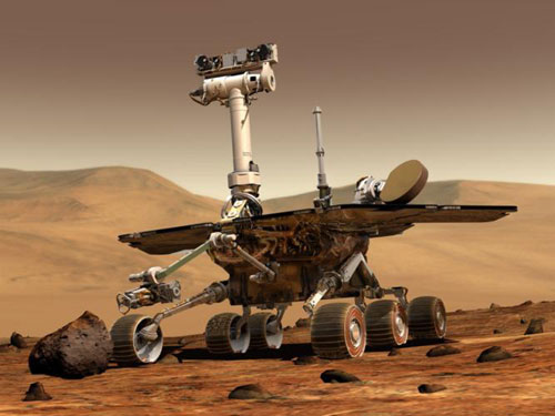


